The name of desert is the term used by the ‘Carmelitas Descalzas’ to designate those lonely places far from the population, to which they retire to dedicate themselves to contemplation and prayer. Since palm trees abounded in the area, the park was renamed ‘Desert de les Palmes’. The lands of the ‘Desert de les Palmes’ have been populated since the Neolithic, although their history really begins with the arrival of the ‘ padres carmelitas’.
Protected by Law for over 20 years, the Natural Park of the ‘Desert de les Palmes’ is located in the province of Castellón. It covers an area of more than 3000 hectares, and is so diverse and dispersed that it occupies part of five municipal areas: Benicàssim, Cabanes, La Pobla Tornesa, Borriol and Castelló de la Plana. It is located in a coastal mountain range of the region of the ‘Plana Alta’, parallel to the coast, with abundant ridges and rocks. From the highest peaks, the ‘mola del Morico’ of 694 meters and the ‘Bartolo’ of 729, the visitor can enjoy the wonderful perspectives that its two peaks offer of the coast.
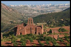
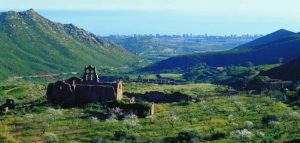
The climate of the park is characterized by being clearly Mediterranean, but its proximity to the sea gives it special climatic characteristics due to the east winds that, loaded with humidity, cause fogs allowing the formation of more humid microclimates. The natural area has a series of ruins and buildings of remarkable interest such as Miravet Castle, Montornés Castle and Old Castle, as well as the hermitage of Les Santes and Magdalena.
 ROUTES
N1- CIRCULAR ITINERARY OF THE INFORMATION CENTER TO BARTOLO
Duration: 2 h – Ascent: 328 m – Distance: 5 km.
N4- ITINERARY OF THE INFORMATION CENTER TO THE POBLA TORNESA
Duration: 1h 30 ‘- Descent: 250 m – Distance: 5’7 km. From the information center through paths and forest roads to the municipality of La Pobla Tornesa.
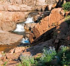
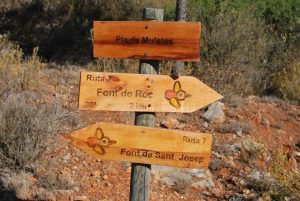
N7- CIRCULAR ITINERARY BY THE SOURCES OF DESERT
Duration: 3 h – Elevation difference: 200 m – Distance: 7 km. Circular route that takes you to visit three of the sources of the ‘Desert de les Palmes’.
N2- CIRCULAR ITINERARY OF THE INFORMATION CENTER TO BARTOLO, FOR THE PEAKS
Duration: 2h 30 ‘- Ascent: 330 m – Distance: 5’5 km. It is one of the routes with more difficulty, since the ascent is quite hard, but the views offered by the mountain are worth it.
N5- ITINERARY OF THE INFORMATION CENTER TO THE CASTLE OF MONTORNÉS
Duration: 1 h – Elevation: 30 m – Distance: 2 km. Enjoy Arab ruins from the 10th century, overlooking the Mediterranean coastline.
N8- ITINERARY OF BENICASIM TO LA FONT TALLÀ.
Duration: 2 h – Elevation: 300 m – Distance: 5’3 km.
N3- CIRCULAR ITINERARY BY THE INFORMATION CENTER, THE BARTOLO AND LES SANTES
Duration: 5 h – Slope: 450 m – Distance: 13.5 km. Circular route through a large part of the natural park, which allows you to know both the coastline and the interior of the protected area.
N6- ITINERARY OF ‘LA FUENTE DEL PERELLÓ’ TO MIRAVET CASTLE
Duration: 1 h – Ascent: 160 m – Distance: 2 km. Find yourselves in one of the castles in the best state of preservation of the whole park, with delicious views of the coast.
N9- CIRCULAR ITINERARY BY THE LES SANTES HERMITAGE
Duration: 1h 15 ‘- Ascent: 150 m – Distance: 3’5 km. Circular route through one of the coolest ravines in the entire space
